
Scientist of the Day - Willem Janszoon Blaeu
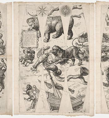
Willem Janszoon Blaeu, a Dutch cartographer, died Oct. 21, 1638, at the age of about 67; his date of birth is unknown. In 1595-96, Blaeu spent 6 months with the astronomer Tycho Brahe on the Danish island of Hven and was given access to Tycho Brahe's catalog of stars, compiled from Tycho’s own observations over many years. In 1599, having returned to his home city of Alkmaar, Blaeu issued his first pair of globes, one terrestrial and one celestial, and the celestial globe was the first to position the stars using the new observations of Brahe (all other star globes to date were based on the star catalog of the ancient Greek astronomer Ptolemy). Only one record of the 1599 celestial globe survives, at Harvard, and it is not a globe but a print – a set of gores, the flat printed map segments that were to be cut out and pasted onto a sphere to make a globe (first image). It is quite a treasure!

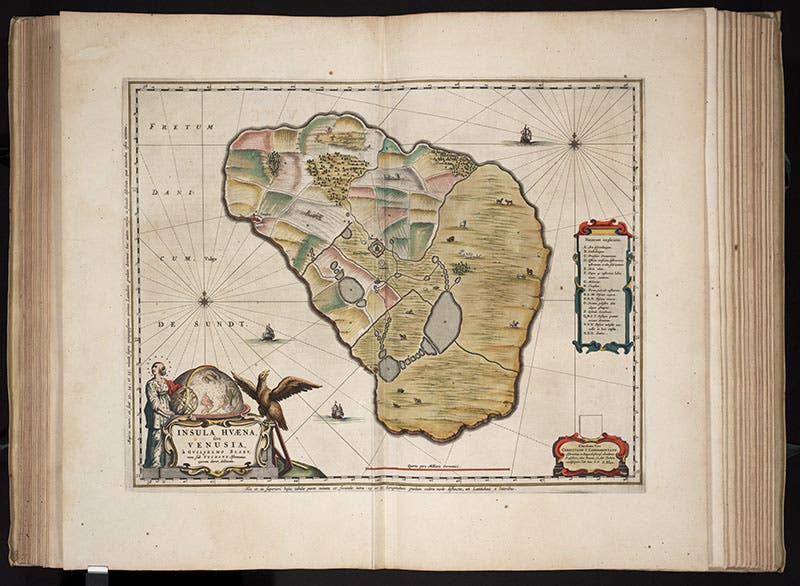
Map of Hven, Danish island and home of Tycho Brahe’s observatory, engraving by Willem Janszoon Blaeu, in Joan Blaeu, Atlas maior, vol. 1, 1662 (Linda Hall Library)
In 1603, Blaeu published another star globe, retaining the Tycho Brahe stars but this time also adding in the new southern constellations as observed by Frederik de Houtman on a southern voyage of 1598-99. Since the 1599 celestial globe is non-existent as a globe, very often Blaeu’s 1599 terrestrial globe is paired with the 1603 celestial globe, as in the Museum of the History of Science at Oxford. These are 15.5-inch globes, and the star globe is on the left. While Blaeu was on Hven, he also made a detailed map of the island, and it was printed over 60 years later in the Atlas Major of his son, Joan Blaeu. We happen to have this atlas in our collection, all 11 glorious volumes of it, and an image of this 1662 printing of the map of Hven is available in our Digital Collections, and also here, as our second image. It is the only known map directly attributed to Willem Janszoon Blaeu. If you zoom in on the bottom left corner, you will see the printed attribution to “Guilielmo Blaeu” (and a good view of one of his celestial globes). Again, we have done this for you and show you a detail of the corner cartouche in our third image. All the other maps and globes issued by Blaeu until his death in 1638 were executed by artists and engravers in his employ.

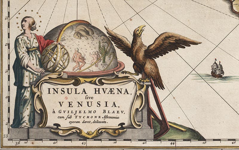
Detail of second image, cartouche at lower left, crediting Willem Janszoon Blaeu for the map and showing one of his celestial globes (Linda Hall Library)
We would like to show you one other Willem Blaeu map, simply because it is in an unusual location. In 1657, the Delft artist Johannes Vermeer painted The Soldier and the Laughing Girl. It now hangs in the Frick Collection in Manhattan. On the back wall, behind the amused girl, is a large map of Holland and West Friesland (click at the link to enlarge). It happens to be a painstakingly accurate copy of a map issued by Willem Blaeu in 1621. Vermeer must have really liked it, because he placed it in two others of his interiors. One of the curious features of the Blaeu map as painted by Vermeer is that the blue areas, which one might guess represent the sea, are actually land. Vermeer originally painted them green, by applying a blue undercoat and then a gloss of yellow. But the yellow pigment has faded over time, and now only the blue shines through. It is almost as if the sea is still trying to reclaim the Low Countries that were stolen from it, even in works of art. Dr. William B. Ashworth, Jr., Consultant for the History of Science, Linda Hall Library and Associate Professor emeritus, Department of History, University of Missouri-Kansas City. Comments or corrections are welcome; please direct to ashworthw@umkc.edu.


