Scientist of the Day - Johann von Charpentier


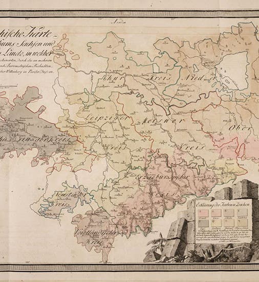
Geological map of Saxony, hand-colored engraving in Johann von Charpentier, Mineralogische Geographie der Chursächsischen Lande, 1778 (Linda Hall Library)
Johann Friedrich Wilhelm von Charpentier, a German geologist and mining engineer, died July 27, 1805, at the age of 67; he was born in Dresden in 1738. Dresden, Leipzig, and Chemnitz are the three principal cities of Saxony, in north-eastern Germany, which in Charpentier's time was an Electorate of the Holy Roman Empire. The principal geographical feature of Saxony is the Erzgebirge or "Ore-bearing mountains", which lie in the south of the electorate and border Bohemia (now the Czech Republic). The Erzgebirge had long been a rich mining district, a source of tin, silver, cobalt, kaolin, and other valuable metals and minerals. Because of the economic importance of the Erzgebirge to the state, a mining academy was established in Freiberg in 1765, with the intention of producing mining engineers to run the various mines, alum, salt, and lime works, and other production plants that had been built in the region. Charpentier was invited to teach mathematics there in 1766, and he quickly rose to become the school's principal authority on geology and mining. He was 11 years older than his colleague, Abraham Gottlob Werner, who came to Freiberg in 1775 to teach mineralogy, and who would soon outshine Charpentier as a teacher of the earth sciences.

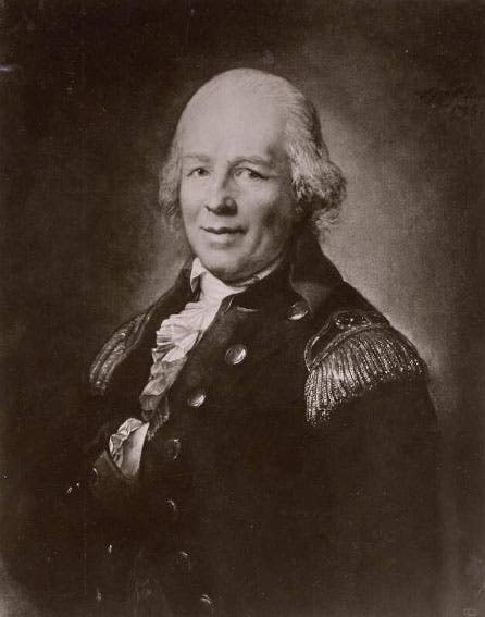
Portrait of Johann von Charpentier, photographic negative on glass of oil portrait by Anton Graff, 1798, whereabouts of original unknown, negative at Freiberg Mining Academy (deutsche-digitale-bibliothek.de)
Because Werner went on to become the best known and most influential geologist in Europe by the end of the century, Charpentier has been greatly overshadowed by Werner, but Charpentier was as keen a student of the stratigraphy and mineralogy of eastern Europe as Werner, and he did two things Werner never did: he wrote a comprehensive book on the "mineralogical geography" of Saxony, called Mineralogische Geographie der Chursächsischen Lande and published in 1778, and he compiled a geological map of Saxony, which was included as a fold-out in the book (first image). We are fortunate to have an attractive copy of Charpentier's book in our collections, with the map in excellent condition.

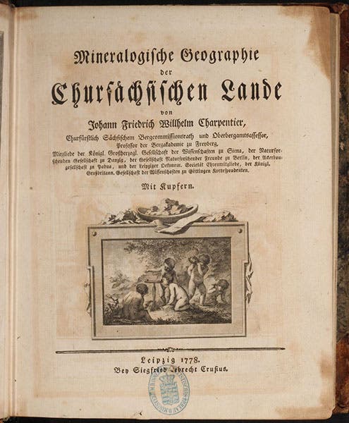
Title page, Johann von Charpentier, Mineralogische Geographie der Chursächsischen Lande, 1778 (Linda Hall Library)
Geological mapping was a new endeavor in 1778. Jean-Étienne Guettard had presented the first geological map of any region (in this case, France and England) to the French Academy of Sciences in 1746, and Nicolas Desmarest had published a geological map of the Auvergne region of central France in 1771, but that was about it. The famous geological maps of Alexandre Brongniart and Georges Cuvier in France (1811), and William Smith in England (1815), were thirty years in the future when Charpentier published his map.

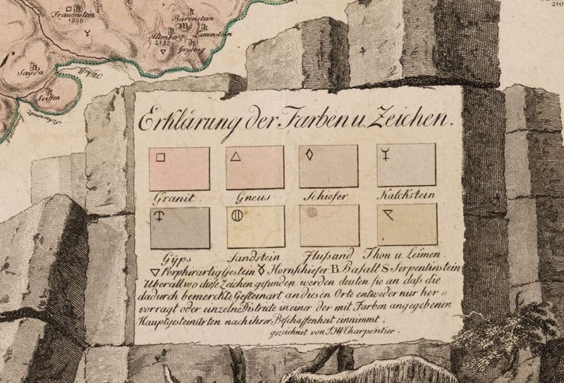
Key to geological map of Saxony (first image), detail of hand-colored engraving in Johann von Charpentier, Mineralogische Geographie der Chursächsischen Lande, 1778 (Linda Hall Library)
The purpose of these early geological maps was to indicate the rocks or rock formations that lie on the surface in different parts of the region being mapped. One can do this with symbols, or with coloring. Charpentier did both. His map of Saxony was hand colored with delicate hues of rose, pink, and yellow, to indicate the presence of granite, gneiss, sandstone, limestone, and shale, and in addition, there were symbols to denote the location of clay, lime, basalt, and other rocks and minerals; basalt is represented by the letter B, and there are “Bs” scattered around the map. There is a key to the color coding and the symbols at the bottom right of the map, which we show in a detail (fourth image).

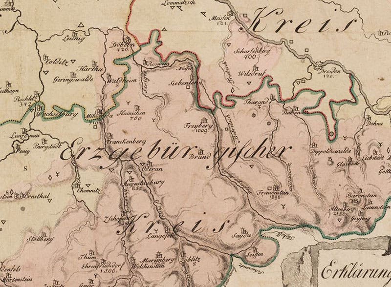
Detail of geological map of Saxony (first image), showing location of Freiberg, hand-colored engraving in Johann von Charpentier, Mineralogische Geographie der Chursächsischen Lande, 1778 (Linda Hall Library)
In another detail, of the Erzgebirge itself, just above and to the left of the key, we can see the city of Freiberg, the site of the Mining Academy where Charpentier and Werner taught (fifth image). It sits just above the “rg” of Erzegebürgischer. If you have difficulty distinguishing the colors on his map, that is because Charpentier probably did not consider that people would be looking at his map 250 years down the road and that perhaps he should use bolder pigments.


Interior of silver mine in Saxony, engraving in Johann von Charpentier, Mineralogische Geographie der Chursächsischen Lande, 1778 (Linda Hall Library)
There are several other full-page engravings in Charpentier’s book besides the map. We show one of those here, the inside of a silver mine in the Erzgebirge, with a good glimpse of a contemporary miner and assayer at work (sixth image).
Werner would become famous as a champion of neptunism, the belief that ALL rock formations are formed under water, including rocks such as granite and basalt, which we now know to be igneous in origin. Interestingly, Charpentier, like Desmarest, was a vulcanist, and believed that some rocks, such as granite, gneiss, and the basalt of France, were cooled from a molten state. However, when it came to the basalt of Saxony, which was not found near any volcanic mountains, Charpentier tended to agree with Werner, that it formed from sediment. You can read more about the vulcanist-neptunist debate in our posts on Desmarest, Werner, Antonio Lazzaro Moro, Alberto Fortis, and James Hutton.

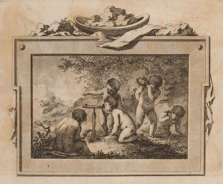
Title-page vignette, engraving in Johann von Charpentier, Mineralogische Geographie der Chursächsischen Lande, 1778 (Linda Hall Library)
The title page of Charpentier’s book is of interest because it has an engraved vignette showing putti at work surveying the land with a plane table and chipping out samples with a rock hammer (seventh image). We have often written about title-page putti in these posts, but putti were mostly creatures of the 17th century. I wrote an article, “Putti in the service of science” in the Winter 2022 issue (no. 68) of the Library’s house journal, The Hedgehog, where all the examples were from the 17th century (you may access the issue here; the putti article begins on page 12). Charpentier’s vignette is close to being a putti swansong.
I looked hard and wide to find a portrait of Charpentier. Apparently, he had his portrait painted in 1798 by the great Swiss portraitist Anton Graff, who had moved to Dresden. But I cannot find it anywhere. The best I could do was locate a photo-negative on glass of the painting, made in 1940, and now in the archives of the Mining Academy of Freiberg (second image). I hope the original was not destroyed in World War II and will turn up someday.
Incidentally, Johann’s son, who went by the name of Jean de Charpentier, became a prominent geologist himself and was one of the first to argue that the erratic boulders strewn about Europe were the result of extensive glaciation during the Ice Age. We have written a post on Jean de Charpentier, where we regrettably failed to even mention his father.
William B. Ashworth, Jr., Consultant for the History of Science, Linda Hall Library and Associate Professor emeritus, Department of History, University of Missouri-Kansas City. Comments or corrections are welcome; please direct to ashworthw@umkc.edu.