Scientist of the Day - Heinrich Berghaus
Heinrich Karl Wilhelm Berghaus, a German cartographer, was born May 3, 1797. Berghaus invented the thematic atlas in 1845. Maps had been around forever, and atlases – collections of maps – since Abraham Ortelius’s Atlas in 1570, or since 140 C.E., if you count Ptolemy's Geographia, which really does deserve to be counted. Traditional maps showed the location of town and cities, rivers, lakes, coastlines, and state and country borders.

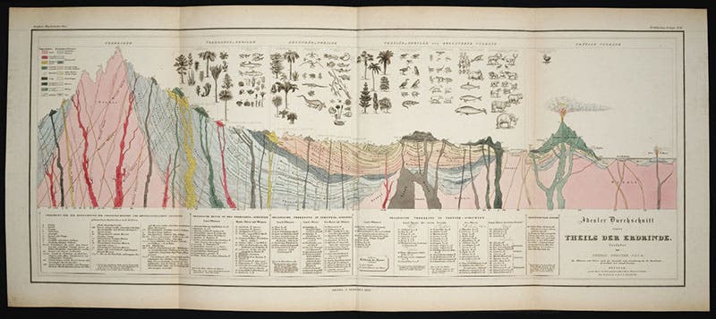
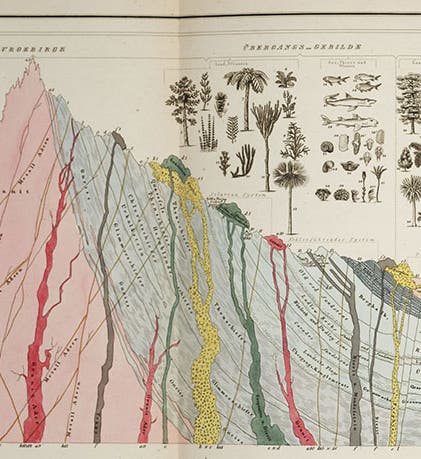
Idealized section of the stratigraphy of the Earth, with representative fossils from those strata, hand-colored engraving, Heinrich Berghaus, Physikalischer Atlas, vol. 1, 1845 (Linda Hall Library)
A thematic map is a geographic map with a twist, adding some other feature that can be mapped. That feature might be the location of coal deposits, or spoken languages, or average annual temperatures. There had been many such maps before Berghaus. Edmond Halley mapped trade winds in 1686, Nicolas Desmarest mapped basalt deposits in France in 1771, and Benjamin Franklin mapped the Gulf Stream in 1786. The first biogeographic map was published by Eberhard von Zimmermann in 1777, when he added to his book on mammals a map that showed the world-wide distribution of mammals. We have written a post on Zimmermann and his map.

![Front cover, indicating that there are 90 [double-page] maps in the complete work, Heinrich Berghaus, Physikalischer Atlas, vol. 1, 1845 (Linda Hall Library)](https://assets-us-01.kc-usercontent.com:443/9dd25524-761a-000d-d79f-86a5086d4774/224b2893-3d7f-46bd-b281-124b9299a227/berghaus3.jpg?w=410&h=600&auto=format&q=75&fit=crop)
Front cover, indicating that there are 90 [double-page] maps in the complete work, Heinrich Berghaus, Physikalischer Atlas, vol. 1, 1845 (Linda Hall Library)
Alexander von Humboldt was really the first to show the power of the biogeographical map. In his Voyage to the Equinoctial Regions of the New World (1805-34), and in his more specialized publications, he mapped such things as the distribution of volcanoes or the variation in plant life by elevation in mountain ranges such as the Andes. But the thematic map as a genre did not really catch on until Berghaus. In the monumental publication that resulted from Napoleon’s invasion of Egypt, the Description de l’Egypte, 1809-1828, there is not a single thematic map, to my recollection.

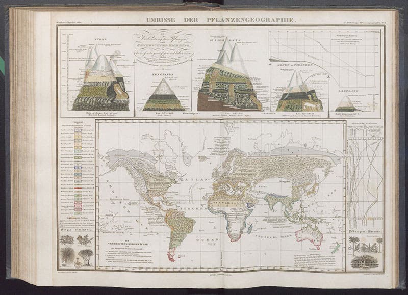
World map of the distribution of plants, with insets showing variation of plant life with elevation, hand-colored engraving, Heinrich Berghaus, Physikalischer Atlas, vol. 1, 1845 (Linda Hall Library)
Berghaus met Humboldt in 1815 and the two became lifelong friends. Berghaus was no doubt influenced by Humboldt’s fondness for biogeography, and there is evidence that Humboldt encouraged Berghaus to produce thematic maps. Berghaus teamed up with the noted map printer Justus Perthes, and he 1838 he began issuing his first thematic maps. By 1845, he had enough maps to publish the first volume of his Physikalischer Atlas. The second volume appeared three years later. Together, the two volumes contain 90 thematic maps, divided into a number of groups, depending on whether the information mapped was geological, meteorological, botanical, ethnographic, etc. Seldom has a discipline had a richer, more glorious beginning than the thematic atlas had in Berghaus.

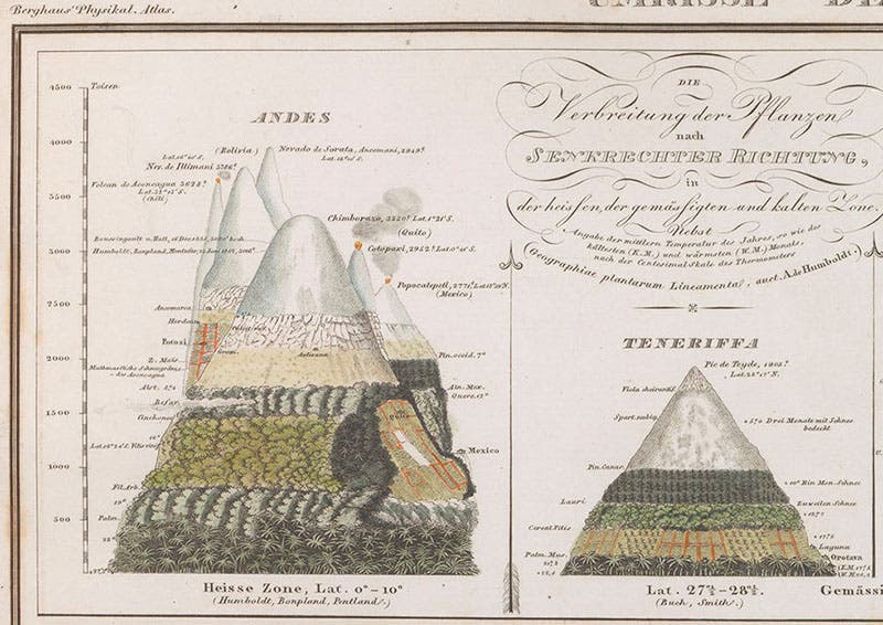
Detail of fourth image, showing plant variation with elevation for the Andes (left) and the Canary Islands, hand-colored engraving, Heinrich Berghaus, Physikalischer Atlas, vol. 1, 1845 (Linda Hall Library)
We show here a small selection of the maps in the two Berghaus volumes, some entire, so you can get an idea of the scope, and some in detail, so you can better see the kind of information that was included. Many of the engraved maps had added hand-coloring, which adds to their attractiveness.
Our first image is a detail of a geological section that shows idealized stratigraphic layers of the Earth’s crust, with the section of a volcano thrown in for good measure. The animals whose fossils are found in the various formations are sketched in at the top, with labels connecting them to the appropriate strata (the full section is shown in our second image). This map was based closely on an engraving by Thomas Webster that was included in William Buckland’s Geology and Mineralogy Considered with Reference to Natural Theology (1836); Berghaus probably saw the German edition that was published in 1838-39.

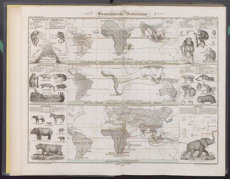
Three world maps showing the distribution of mammals, such as old-world monkeys, marsupials, and pachyderms, engraving, Heinrich Berghaus, Physikalischer Atlas, vol. 2, 1848 (Linda Hall Library)
Our fourth image is a world map of the distribution of plants on Earth, with insets at the top that indicate that biogeography is three-dimensional, with plants varying by altitude as well as by longitude and latitude. We show a detail of the top left corner, illustrating how vegetation changes on the slopes of the mountains of the Andes, and on Teneriffe, in the Canary Islands (fifth image). These kinds of mountain-elevation phytogeographical maps were originated by and inspired by Humboldt.

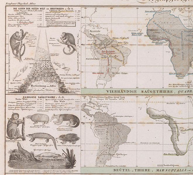
Detail of sixth image, insets showing monkeys of the New World, and edentates of the New World, Heinrich Berghaus, Physikalischer Atlas, vol. 2, 1848 (Linda Hall Library)
The third engraving we reproduce shows the world-wide distribution of mammals, with three world maps on the one plate (sixth image). Each map concentrates of two or three orders of mammals; the first map, for example, locates the New World monkeys in South America and the Old World monkeys in Africa and Asia. In addition, insets along the side depict the animals being mapped. We show a detail of the upper left, where you can see a capuchin and a howler monkey, along with another elevation map; below are a variety of edentates, such as sloths and armadillos (seventh image). We also include a map showing the distribution of human types around the world (eighth image). There are many other fine maps that we don’t have space to include, such as an amazing plate that maps the world-wide distribution of human diseases.

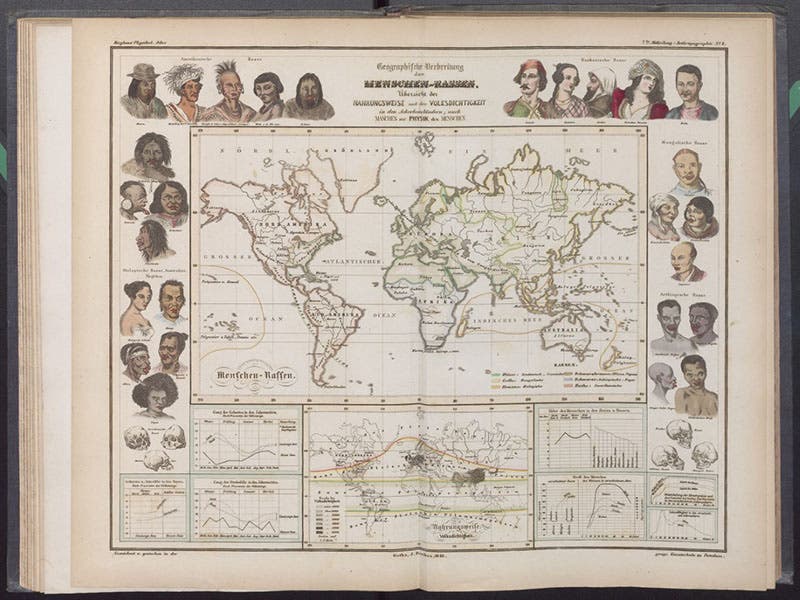
Peoples of the world, world map with insets, hand-colored engraving, Heinrich Berghaus, Physikalischer Atlas, vol. 2, 1848 (Linda Hall Library)
Berghaus planned to team up with a Scotsman, Alexander Keith Johnston, to publish an English version of his atlas; that didn’t quit work out, and Johnston instead published his own Physical Atlas (1848), obviously based on that of Berghaus, but with many new kinds of thematic maps inspired by Scottish and English scientific work. Johnston also realized that a smaller, less bulky atlas might appeal to a wider audience, and published several reduced versions as well. We have written a post on Johnston. The thematic atlas was off and running, and the appeal of such an atlas has not diminished since Berghaus invented it in 1845.
Not too long ago, we wrote a post on John Bartholomew, whose Atlas of Zoogeography was published in 1911. It is interesting to compare the two atlases, to see how mapping styles can change in 65 years.
Dr. William B. Ashworth, Jr., Consultant for the History of Science, Linda Hall Library and Associate Professor emeritus, Department of History, University of Missouri-Kansas City. Comments or corrections are welcome; please direct to ashworthw@umkc.edu.